
Japan braces as Typhoon Lan to make landfall on Tuesday
A powerful typhoon, named Typhoon Lan, is expected to make landfall Tuesday in western and central Japan, with warnings of heavy rain.
Tokyo: A powerful typhoon, named Typhoon Lan, is expected to make landfall Tuesday in western and central Japan, with forecasts predicting heavy rain, mudslides, and flooding that may disrupt the country’s annual Bon summer holidays.
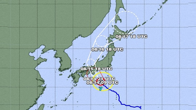
The Japan Meteorological Agency issued a cautionary message as Typhoon Lan currently advances south of the Izu island chain, with its impact expected to be felt in eastern and western Japan from Monday to Tuesday.
Anticipating the typhoon’s potential consequences, West Japan Railway Co. has alerted the public about the likelihood of delays or suspensions in train services starting Monday.
As of 9 a.m., Typhoon Lan was positioned approximately 380 kilometres south of Hachijo Island, moving gradually northwestward. Its atmospheric pressure measures 965 hectopascals, and winds have reached speeds of up to 198 kilometres per hour.
The typhoon’s projected trajectory indicates a northward movement through the Sea of Japan by Wednesday. The Tokai region in central Japan is expected to bear the brunt of the rainfall, with precipitation amounts ranging from 300 to 500 millimetres over the 24-hour period leading up to 6 a.m. Monday.
Additionally, the Kanto-Koshin and Kinki regions may experience up to 300 millimetres of rainfall during the same period.

 Ms Kalinga