
Low pressure area forms over Bay Of Bengal, heavy rain to lash Odisha till Oct 3
Under the influence of the cyclonic circulation over Myanmar and the adjoining east-central BoB , a low-pressure area has formed
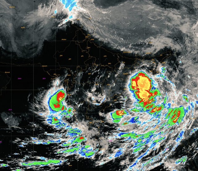
Bhubaneswar: Under the influence of the cyclonic circulation over Myanmar and the adjoining east-central Bay of Bengal, a low-pressure area has formed over the northeast and adjoining east-central Bay of Bengal with the associated cyclonic circulation extending up to 7.6 km above mean sea level.
According to the India Meteorological Department (IMD), the low pressure may develop into a well-marked low-pressure area and move northwestwards towards north Odisha and adjoining West Bengal coasts during the next 48 hours. As a result, rainfall is likely to increase in Odisha from Friday and continue on October 3.
The Regional Meteorological Centre here has issued Yellow Warning for several districts of Odisha for today over possibility of rainfall.
“Heavy Rainfall very likely to occur at one or two places over the districts of Keonjhar, Mayurbhanj, Balasore and Bhadrak,” the Meteorological Centre predicted.
“Thunderstorm with lightning very likely to occur at one or two places over the districts of Balasore, Bhadrak, Jajpur, Kendrapada, Jagatsinghpur, Cuttack, Khordha, Puri, Nayagarh, Ganjam, Gajapati, Mayurbhanj, Keonjhar, Angul, Dhenkanal, Sundargarh, Kandhamal, Malkangiri, Koraput Nabarangpur, and Rayagada,” it forecasted.
For the next four days, several regions across Odisha will experience thunderstorms along with light and moderate showers. An orange warning has been issued for heavy rainfall in some districts on October 1 and October 2.
Also Read: Odisha Rainfall: Low Pressure To Form Over BoB Today, Yellow Warning Issued To 4 Districts

 Ms Kalinga