
Depression intensified into deep depression over west-central BoB, Odisha SRC alerts district collectors
Light to moderate rain/ thundershower very likely to occur at one or two places over the districts of coastal Odisha and dry weather likely over the rest districts of Odisha.
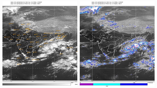
Bhubaneswar: The India Meteorological Department (IMD) today informed that the Depression over west-central Bay of Bengal moved nearly northwards with a speed of 17 kmph during past 6 hours, intensified into a deep depression and lay centered at 1730 hours IST of today, the 22nd October over the same region, near latitude 16.2°N and longitude 86.4°E about 450 km south of Paradip (Odisha), 560 km south-southwest of Digha (West Bengal), and 750 km south-southwest of Khepupara (Bangladesh).
It is likely to intensify further into a cyclonic storm during next 24 hours. It is likely to move nearly northwards till morning of 23rd October, then north-northeastwards and cross Bangladesh coast between Khepupara and Chittagong around 25th October evening as a deep depression, said the IMD.
WEATHER WARNING:
Day-1: Valid up to 0830 hrs IST of 23.10.2023:
- Light to moderate rain/ thundershower very likely to occur at one or two places over the districts of coastal Odisha and dry weather likely over the rest districts of Odisha.
Day-2: Valid from 0830 hrs IST of 23.10.2023 up to 0830 hrs IST of 24.10.2023:
- Light to moderate rain/ thundershower very likely to occur at a few places over the districts of coastal odisha, at one or two places over the districts of Keonjhar, Mayurbhanj, Angul, Dhenkanal, Boudh, Kandhamal, Rayagada, Koraput, Malkangiri and dry weather likely over the rest districts of Odisha.
Day-3: Valid from 0830 hrs IST of 24.10.20 23 up to 0830 hrs IST of 25. 0.2023:
- Light to moderate rain/ thundershower very likely to occur at many places over the districts of north coastal Odisha, at a few places over the districts of south coastal Odisha, Keonjhar, Mayurbhanj, Dhenkanal and at one or two places over the rest districts of Odisha.
Day-4: Valid from 0830 hrs IST of 25.10.20 23 up to 0830 hrs IST of 26. 0.2023:
- Light to moderate rain/ thundershower very likely to occur at a few places over the districts of coastal Odisha, Keonjhar, Mayurbhanj, Dhenkanal and at one or two places over the rest districts of Odisha.
Day-5: Valid from 0830 hrs IST of 26.10.20 23 up to 0830 hrs IST of 27. 0.2023:
- Light to moderate rain/ thundershower very likely to occur at one or two places over the districts of Mayurbhanj, Balasore and Bhadrak and dry weather likely over the rest districts of Odisha.
Meanwhile, the Special Relief Commissioner (SRC) has asked the district collectors to stay alert and take the following steps:
- Districts under warning to keep administrative machinery ready to face any eventuality.
- In urban areas, low-lying areas may have water logging, and roads/drains may be submerged under water.
- In case of very heavy rain, people of low-lying areas may be shifted to safer locations temporarily.
- ULBs must keep the drains/storm water channels de-congested, and adequate de-watering pumps may be deployed as per requirement.
- People may be advised to keep watch on the weather and take safe shelter during the thunderstorm activity to protect from lightning and follow traffic advisories in urban areas.
- Heavy to very heavy rainfall recorded may be reported immediately to the office.
- Submit report on damage, if occurred due to thunderstorm, whirlwind, hailstorm, lightning and heavy rainfall immediately for information of the government.
Fishermen warning:
- Fishermen are advised not to venture into west-central Bay of Bengal till 25th October and along and off Odisha coast and North Bay of Bengal during 23rd to 26th October 2023. Fishermen whoever in deep sea are advised to return to the coast.

 Ms Kalinga