
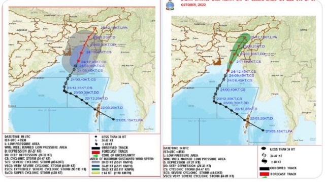
Bhubaneswar: The India Meteorological Department (IMD) in its latest bulletin informed that the cyclonic storm “Sitrang” over north Bay of Bengal moved north-northeastwards with a speed of 28 kmph during past 06 hours & lay centered at 2030 hours IST of today, the 24 th October over the same region near latitude 21.4 0N and longitude 90.2 0E, about 220 km east of Sagar Island and 150 km south of Barisal (Bangladesh).
The IMD further said that the cyclonic storm is very likely to continue to move north-northeastwards and cross Bangladesh coast between Tinkona Island and Sandwip close to Barisal during early hours of tomorrow, October 25, 2022.
Warnings:
(i) Rainfall (warning graphics enclosed) West Bengal: Light to moderate rainfall at most places with isolated heavy rainfall is likely over coastal districts of West Bengal (South & North Parganas) during next 03 hours and decrease in intensity thereafter.
Northeastern States: Light to moderate rainfall at most places with heavy to very heavy rainfall at isolated places is likely over North Assam, Arunachal Pradesh, Nagaland & Manipur; heavy to Extremely heavy rainfall likely over South Assam, Meghalaya, Mizoram, & Tripura on 24th October.
Light to moderate rainfall at most places with isolated heavy to very heavy rainfall is likely over Arunachal Pradesh, Assam, Meghalaya, Mizoram, & Tripura on 25th and isolated heavy rainfall is likely over Arunachal Pradesh, northeast Assam and Nagaland on 26th October.
(ii) Wind warning: Gale wind speed reaching 80-90 kmph gusting to 100 kmph prevailing over north Bay of Bengal and along and off Bangladesh coast. It would continue over the same region during next 6 hours and gradually decrease thereafter becoming 40-50 kmph gusting to 60 kmph by forenoon of 25th October.
Squally wind speed reaching 50-60 kmph gusting to 70 kmph is prevailing along & off West Bengal coast and 40-50 kmph gusting to 50 kmph along & off north Odisha coast. It would continue over the same region during next 6 hours and gradually decrease thereafter becoming 30-40 kmph gusting to 50 kmph by forenoon of 25th October.
Squally wind speed reaching 40-50 kmph gusting to 60 kmph is likely over Mizoram & Tripura from tonight. It would increase gradually becoming wind speed reaching 50-60 kmph gusting to 70 kmph over Tripura and 45-55 kmph gusting to 65 kmph is likely over Mizoram, south Assam and adjoining east Meghalaya & Manipur during early hours to afternoon of 25th October and decrease thereafter gradually.
(iii) Sea condition
High Sea conditions are prevailing over North Bay of Bengal and along and off Bangladesh coast. It would continue during next 06 hours over the same region and improve gradually thereafter becoming rough to very rough for subsequent 12 hours. Rough to very rough Sea conditions likely to prevailing along & off Odisha-West Bengal coasts during next 12 hours and improve gradually thereafter.
(iv) Storm Surge Warning (warning graphics enclosed)
- Tidal wave of about 2.0 m height above astronomical tide is likely to inundate low lying areas of Bangladesh coast during next 06 hours and gradually decrease thereafter.
- Tidal wave of about 0.5 to 1.0 m height above astronomical tide is likely to inundate low lying areas of West Bengal (North & South 24 Parganas) and gradually decrease thereafter.
(v) Fishermen Warning (warning graphics enclosed) Fishermen are advised not to venture into central Bay of Bengal on 24th , north & adjoining central Bay of Bengal on 24th and 25th October, 2022. Fishermen are advised not to venture into Sea along and off Odisha, West Bengal & Bangladesh coasts during 24th to 25th October.
(vi) Damage expected over coastal districts of West Bengal (South and North 24 Parganas including Sundarbans)
- Damage to thatched huts.
- Damage to power and communication lines due to breaking of branches.
- Major damage to Kutcha and minor damage to Pucca roads.
- Damage to paddy crops, banana, papaya trees and orchards.
- Sea water inundation in low lying areas after erosion of Kutcha embankments
- Adverse impact on flora & fauna and animal lives of Sundarbans.
(vii) Damage expected over Tripura, Mizoram, Meghalaya, Manipur and South Assam
- Damage to standing crops including agricultural and horticultural crops due to heavy rain and squally winds.
- Breaking of tree branches and uprooting of small tress like drumsticks, banana and papaya trees.
- Inundation/localized flooding in low lying areas due to heavy rains.
- Localized landslides/ mudslides/ mud slips/ mud sink possibility due to heavy rain.
- Traffic may be disrupted due to poor visibility in association with heavy rain.
- Vulnerable structures like hoardings, tents and display boards may be damaged.
(viii) Action suggested for West Bengal
- Total suspension of fishing operations till 25th forenoon.
- People to remain in safe places during next 06 hours.
(ix) Action suggested for Tripura, Mizoram, Meghalaya, Manipur and South Assam
- People are advised to be cautious while going outside.
- Regulate traffic.
- People should not move nearby to vulnerable structures.
(x) Advisory for On-shore and Off-shore Installations
- Regulation/Suspension of off-shore activities over central and North Bay of Bengal and along & off Odisha and West Bengal coasts till 25th October morning.
- The system is under continuous surveillance and the next message will be issued at 0230 hours IST of tomorrow, the 25 th October, 2022.

 Ms Kalinga