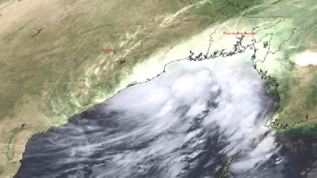
Bhubaneswar: The cyclonic storm Sitrang over Bay of Bengal is likely to intensify into a severe cyclonic storm in next twelve hours. The Regional Meteorological Department of IMD has informed about the active cyclone today early in the morning. The deep depression over the west-central Bay of Bengal had intensified into the cyclonic storm Sitrang at around 5,40 pm yesterday.
The weather department has informed that the cyclone Sitrang is moving towards north-northeast direction with a speed pf 12km/hr in last six hours. The cyclonic storm hence, likely to intensify into a severe cyclonic storm in next 12 hours.
As per the information, the active cyclonic storm is 500 km away from Sagar Island.
On October 23, the weather department informed that the deep depression over the west-central & adjoining east-central Bay of Bengal moved nearly northwards with a speed of 11 kmph during past 6 hours, intensified into a cyclonic storm “SITRANG” and lay centered at 5.30 PM yesterday over the same region near latitude 16.4N and longitude 88.1E, about 730 km northwest of Port Blair, 580 km south of Sagar Island and 740 km south-southwest of Barisal (Bangladesh).
ଆଗାମୀ ୧୨ ଘଣ୍ଟା ମଧ୍ୟରେ ଗୋଟିଏ ଭୀଷଣ ବାତ୍ୟାର ରୂପ ନେବାର ସମ୍ଭାବନା
ଏହା ବର୍ତ୍ତମାନ ସାଗର ଦ୍ଵୀପପୁଞ୍ଜ ଠାରୁ ଦକ୍ଷିଣ ଦିଗରେ ୫୦୦ କିମି ଦୂରରେ ପୂର୍ବ କେନ୍ଦ୍ରୀୟ ପାର୍ଶ୍ଵବର୍ତ୍ତୀ ପଶ୍ଚିମ କେନ୍ଦ୍ରୀୟ ବଙ୍ଗୋପସାଗର ଅଞ୍ଚଳରେ କେନ୍ଦ୍ରୀଭୂତ ରହିଛି pic.twitter.com/1whCqEngYR
— Meteorological Centre, Bhubaneswar (@mcbbsr) October 24, 2022
ଏହା ଆଗାମୀ ୧୨ ଘଣ୍ଟା ମଧ୍ୟରେ ଗୋଟିଏ ଭୀଷଣ ବାତ୍ୟାର ରୂପ ନେବାର ସମ୍ଭାବନା ରହିଛି
ଏହା ବର୍ତ୍ତମାନ ସାଗର ଦ୍ଵୀପପୁଞ୍ଜ ଠାରୁ ଦକ୍ଷିଣ ଦିଗରେ ୫୦୦ କିମି ଦୂରରେ ପୂର୍ବ କେନ୍ଦ୍ରୀୟ ପାର୍ଶ୍ଵବର୍ତ୍ତୀ ପଶ୍ଚିମ କେନ୍ଦ୍ରୀୟ ବଙ୍ଗୋପସାଗର ଅଞ୍ଚଳରେ କେନ୍ଦ୍ରୀଭୂତ ରହିଛି
— Meteorological Centre, Bhubaneswar (@mcbbsr) October 24, 2022


 Ms Kalinga