
IMD issues red warning for heavy to very heavy rainfalls in Odisha in view of Cyclone Montha
The regional centre of the India Meteorological Department (IMD) issued red warning for heavy to very heavy rainfalls in Odisha in view of Cyclone Montha.
Bhubaneswar: The regional centre of the India Meteorological Department (IMD) issued red warning for heavy to very heavy rainfalls in Odisha in view of Cyclone Montha.
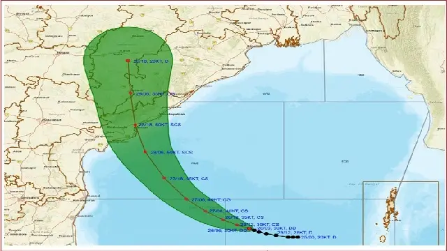
According to the IMD, the deep depression over southeast Bay of Bengal moved northwestwards with a speed of 5 kmph during past 6 hours, and lay centred at 1130 hrs IST of today, the 26th October 2025, over the same region, near latitude 11.3°N & longitude 87.0°E, about 620 km west of Port Blair (Andaman & Nicobar Islands), 770 km east-southeast of Chennai (Tamil Nadu), 820 km south-southeast of Visakhapatnam (Andhra Pradesh), 810 km southeast of Kakinada (Andhra Pradesh) and 920 km south-southeast of Gopalpur (Odisha).
The weather department further said that it is likely to move nearly west-northwestwards, intensify further into a cyclonic storm over southwest & adjoining westcentral Bay of Bengal during next 12 hours. Thereafter, it is likely to move northwestwards, then north-northwestwards and intensify into a severe cyclonic storm by morning of 28th October. Continuing to move further north-northwestwards, it is very likely to cross Andhra Pradesh coast between Machilipatnam and Kalingapatnam around Kakinada during evening/night of 28th October as a severe cyclonic storm with a maximum sustained wind speed of 90-100 kmph gusting to 110 kmph.
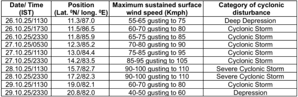
Forecast location and intensity are given in following table:
Forecast in association with anticipated system:
- Day 1: (Valid upto 8.30 AM of October 27) Light to moderate rain or Thundershower very likely to occur at one or two places over the districts of Odisha.
- Day 2: (Valid from 8.30 AM of October 27 to 8.30 AM of October 28) Light to moderate rain or Thundershower very likely to occur at many places over the districts of Interior Odisha and at one or two places over the districts of Coastal Odisha.
- Day 3: (Valid from 8.30 AM of October 28 to 8.30 AM of October 29) Light to moderate rain or Thundershower very likely to occur at most places over the districts of Odisha.
- Day 4: (Valid from 8.30 AM of October 29 to 8.30 AM of October 30) Light to moderate rain or Thundershower very likely to occur at most places over the districts of Odisha.
- Day 5: (Valid from 8.30 AM of October 30 to 8.30 AM of October 31) Light to moderate rain or Thundershower very likely to occur at one or two places over the districts of Odisha.
Heavy rainfall warning for next seven days as follows:
Day 1 (Valid upto 8.30 AM of October 27):
- Nil
Day 2 (Valid from 8.30 AM of October 27 to 8.30 AM of October 28):
- Orange warning: Heavy to very heavy rainfall (7 to 20cm) very likely to occur at isolated places in the districts of Malkangiri, Koraput, Nabarangpur, Kalahandi, Rayagarh, Gajapati, Ganjam, and Kandhamal.
- Yellow Warning: Heavy rainfall (7 to 11cm) very likely to occur at isolated places in the districts of Nuapada, Balangir, Boudh, Nayagarh, Khurda, Puri, Cuttack, Kendrapada, and Jagatsinghpur.
Day 3 (Valid from 8.30 AM of October 28 to 8.30 AM of October 29):
- Red warning: Scattered heavy to very heavy falls (7 to 20cm) with isolated extremely heavy rainfall (>20cm) very likely to occur at isolated places in the districts of Malakangiri, Koraput, Rayagarh, Gajpati, and Ganjam.
- Orange warning: Heavy to very heavy rainfall (7 to 20cm) very likely to occur at isolated places in the districts of Nabarangpur, Kalahandi, Kandhmal, Nayagarh, Khorda and Puri.
- Yellow Warning: Heavy rainfall (7 to 11cm) very likely to occur at isolated places in the districts of Nuapada, Balangir, Sonepur, Bouadh, Angul, Dhenkanla, Cuttack, Jagatsinghpur, Kendrapada, Jajpur, Keonjhar, Bhadrak, Balasore, Mayurbhanj, Bargarh, Sambhalpur and Deogarh.
Day 4 (Valid from 8.30 AM of October 29 to 8.30 AM of October 30):
- Red warning: Scattered heavy to very heavy falls (7 to 20cm) with isolated extremely heavy rainfall (>20cm) very likely to occur at isolated places in the districts of Malakangiri, Koraput, Nabarangpur, Kalahandi and Rayagarh.
- Orange warning: Heavy to very heavy rainfall (7 to 20cm) very likely to occur at isolated places in the districts of Nuapada, Balangir, Boudh, Kandhamal, Gajapati, and Ganjam.
- Yellow Warning: Heavy rainfall (7 to 11cm) very likely to occur at isolated places in the districts of Bargarh, Jharsuguda, Deogarh, Sambhalpur, Sonepur, Angul, Dhenkanal, Nayagarh, Cuttack, Khurda, Puri, Jagatsinghpur, Sundargarh, Keonjhar Mayurbhanj, Balasore, Bhadrak, Jajpur, and Kendrapada.
Day 5 (Valid from 8.30 AM of October 30 to 8.30 AM of October 31):
- Yellow Warning: Heavy rainfall (7 to 11cm) very likely to occur at isolated places in the districts of Jarsuguda, Sundargarh, Sambalpur, Deogarh, Keonjhar, and Mayurbhanj.
Wind Warning for sea area & Sea conditions:
Eastcentral Bay of Bengal:
- Wind Warning: Squally weather with wind speed reaching 50-60 kmph gusting to 70 kmph is prevailing over southeast Bay of Bengal and adjoining areas of Eastcentral Bay of Bengal.
- Sea Condition: Very rough sea condition is prevailing over southeast and adjoining areas of Eastcentral Bay of Bengal and is likely to be high from 26th evening till 28th morning.
West central Bay of Bengal:
- Winds will further increase, becoming Gale wind speed reaching 60-70 kmph gusting to 80 kmph over southwest and adjoining areas of southeast & West central Bay of Bengal Bay of Bengal from 26th October evening.
- Sea conditions is very likely to be high to very high over westcentral Bay of Bengal from 27th October evening, becoming very high from 28th October morning till 29th early hours. Thereafter, it would start improving becoming high to very rough by noon of 29th and becoming very rough to rough during subsequent 12 hours.
Northwest Bay of Bengal:
- Thereafter winds would further increase becoming 80-90 kmph gusting to 100 kmph over westcentral and adjoining northwest Bay of Bengal from 27th October evening and would further increase 90 to 100 kmph from 28th October morning.
- Sea conditions is very likely to be high to very high northwest Bay of Bengal from 27th October evening, becoming very high from 28th October morning till 29th early hours. Thereafter, it would start improving becoming high to very rough by noon of 29th and becoming very rough to rough during subsequent 12 hours.
Along & off Odisha coasts:
- Squally weather with wind speed reaching 35-45 kmph gusting to 55 kmph is likely to prevail along & off south Odisha coast from 26th evening. It is likely to increase becoming 45-55 kmph gusting to 65 kmph from 27th evening and becoming gale wind speed reaching, 60-70 kmph gusting to 80 kmph from 28th evening to early hours of 29th October early hours along and off south Odisha coast, becoming 45- 55 kmph gusting to 65 kmph till 29th October evening and decrease gradually thereafter. Squally wind speed reaching 50-60 kmph gusting to 70 kmph is likely to prevail from 28th evening to early hours of 29th October early hours along and off north Odisha coast, becoming 40-50 kmph gusting to 60 kmph till 29th October evening and decrease gradually thereafter.
- Sea conditions are very likely to be rough to very rough along & off Odisha coast from 26th evening to 27th evening. It would worsen further becoming high from 28th morning to till 29th October early hours. It is likely improve gradually becoming very rough to rough during subsequent 12 hours.
Fishermen Warning:
- Fishermen are advised not to venture into Southwest, adjoining central Bay of Bengal, along & off Odisha coast till 29th October. Those out at sea area should return to the coast immediately.
Port Warning Signals:
- Hoist Distant Cautionary Signal No-I (DC-1) at all Ports of Odisha.