
IMD forecasts cyclonic storm over Bay of Bengal, issues seven days’ rain warning in Odisha
The low pressure area over southeast Bay of Bengal slowly moved west-north-westwards during past 3 hours and lay over the same region today, said the regional centre of the India Meteorological Department (IMD).
Bhubaneswar: The low pressure area over southeast Bay of Bengal slowly moved west-north-westwards during past 3 hours and lay over the same region today, said the regional centre of the India Meteorological Department (IMD).
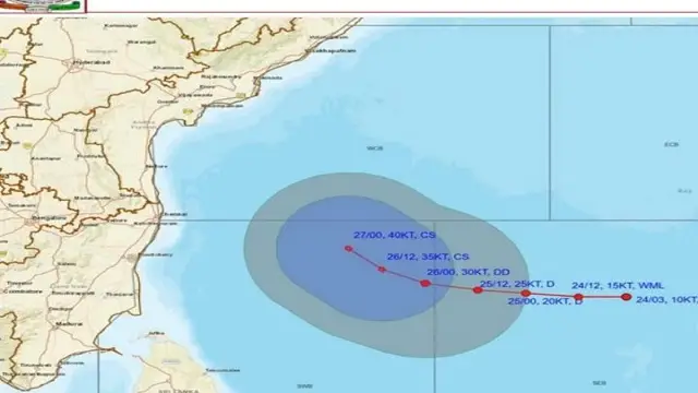
The weather department further said that the low pressure area is likely to move west-north-westwards, intensify into a depression over southeast and adjoining central Bay of Bengal by 25th and further into a deep depression by 26th and into a cyclonic storm over southwest & adjoining west-central Bay of Bengal by 27th morning.
In view of this, the following heavy rain warnings issued for parts of Odisha:
Day 1 (Valid upto 8.30 AM of October 25):
- YELLOW WARNING: Thunderstorm with lightning accompanied with gusty surface wind speed reaching 30-40 kmph likely to occur at one or two places over the districts of Rayagada, Koraput, Malkangiri, Kandhamal, Puri, Khurda, Ganjam, Gajapati, Jagatsinghpur and Kendrapara.
- Light to moderate rain or Thunderstorm very likely to occur at one or two places over the districts of Rayagada, Koraput, Malkangiri, Kandhamal, Puri, Khurda, Ganjam, Gajapati, Jagatsinghpur, Kendrapara and dry weather likely to prevail over the rest districts of Odisha.
Day 2 (Valid from 8.30 AM of October 25 to 8.30 AM of October 26):
- YELLOW WARNING: Thunderstorm with lightning accompanied with gusty surface wind speed reaching 30-40 kmph likely to occur at one or two places over the districts of Balasore, Bhadrak, Jajpur, Kendrapara, Cuttack, Jagatsinghpur, Puri, Khurda, Nayagarh, Ganjam, Gajapati, Rayagada, Koraput, Malkangiri, Kandhamal, Kalahandi and Nabarangpur.
- Light to moderate rain or thunderstorm very likely to occur at one or two places over the districts of Coastal Odisha, Rayagada, Koraput, Malkangiri, Kandhamal, Kalahandi, Nabarangpur and dry weather likely to prevail over the rest districts of Odisha.
Day 3 (Valid from 8.30 AM of October 26 to 8.30 AM of October 27):
- YELLOW WARNING: Thunderstorm with lightning accompanied with gusty surface wind speed reaching 30-40 kmph likely to occur at one or two places over the districts Balasore, Bhadrak, Jajpur, Kendrapara, Cuttack, Jagatsinghpur, Puri, Khurda, Nayagarh, Ganjam, Gajapati, Malkangiri, Kandhamal, Rayagada, Koraput, Mayurbhanj, Keonjhar, Dhenkanal and Boudh.
- Light to moderate rain or thunderstorm very likely to occur at a few places over the districts of Coastal Odisha, Malkangiri, Kandhamal, Rayagada, Koraput, Mayurbhanj, Keonjhar, Dhenkanal and Boudh and at one or two places over the rest districts of Odisha.
Day 4 (Valid from 8.30 AM of October 27 to 8.30 AM of October 28):
- YELLOW WARNING: Heavy rain and thunderstorm with lightning accompanied with gusty surface wind speed reaching 30-40 kmph likely to occur at one or two places over the districts of Kendrapara, Cuttack, Jagatsinghpur, Puri, Khurda, Ganjam, Gajapati, Nayagarh, Malkangiri, Rayagada and Koraput.
- Thunderstorm with lightning accompanied with gusty surface wind speed reaching 30-40 kmph likely to occur at one or two places over the districts of Balasore, Bhadrak, Jajpur, Sundargarh, Jharsuguda, Bargarh, Sambalpur, Deogarh, Angul, Dhenkanal, Keonjhar, Mayurbhanj,Sonepur, Boudh, Nuapada, Bolangir, Kalahandi, Kandhamal and Nabarangpur.
- Light to moderate rain or thunderstorm very likely to occur at many places over the districts of Odisha.
Day 5 (Valid from 8.30 AM of October 28 to 8.30 AM of October 29):
- ORANGE WARNING: Heavy to very heavy rain and thunderstorm with lightning accompanied with gusty surface wind speed reaching 30-40 kmph likely to occur at one or two places over the districts of Kendrapara, Jagatsinghpur, Cuttack, Puri, Khurda and Ganjam.
- YELLOW WARNING: Heavy rain and thunderstorm with lightning accompanied with gusty surface wind speed reaching 30-40 kmph likely to occur at one or two places over the districts of Koraput, Malkangiri ,Gajapati, Rayagada, Kandhamal, Boudh, Nayagarh, Dhenkanal, Angul, Keonjhar, Mayurbhanj, Balasore, Bhadrak and Jajpur.
- Thunderstorm with lightning accompanied with gusty surface wind speed reaching 30-40 kmph likely to occur at one or two places over the districts of Bhadrak, Jajpur, Sundargarh, Jharsuguda, Bargarh, Sambalpur, Deogarh, Sonepur, Boudh, Nuapada, Bolangir, Kalahandi and Nabarangpur.
- Light to moderate rain or thunderstorm very likely to occur at most places over the districts of Odisha.
Day 6 (Valid from 8.30 AM of October 29 to 8.30 AM of October 30):
- ORANGE WARNING: Heavy to very heavy rain and thunderstorm with lightning likely to occur at one or two places over the districts of Balasore, Mayurbhanj and Bhadrak.
- YELLOW WARNING: Heavy rain and thunderstorm with lightning likely to occur at one or two places over the districts of Jajpur, Keonjhar, Kendrapara and Jagatsinghpur.
Day 7 (Valid from 8.30 AM of October 30 to 8.30 AM of October 31):
- Light to moderate rain or thunderstorm very likely to occur at a few places over the districts of Coastal Odisha and at one or two places over the districts of Interior Odisha.
Wind warning:
- Squally weather with wind speed reaching 35-45 kmph gusting to 55 kmph is likely to prevail over southeast Bay of Bengal and Andaman Sea & adjoining areas of Eastcentral Bay of Bengal till 24th October. It is likely to increase becoming squally wind speed reaching 50-60 kmph gusting to 70 kmph over central parts of Bay of Bengal on 25th and Gale wind speed reaching 60-70 kmph gusting to 80 kmph from 26th October evening onwards till 27th evening. It is likely to increase becoming Gale wind speed reaching 70-80 kmph gusting 90 kmph over westcentral and adjoining northwest Bay of Bengal till 29th October.
- Squally weather with wind speed reaching 35-45 kmph gusting to 55 kmph is likely to prevail along & off Tamil Nadu – Puducherry coast from 25th to 28th October, along & off Squally weather with wind speed reaching 35- 45 kmph gusting to 55 kmph is likely to prevail along & off Andhra Pradesh coast from 25th October. It is likely to increase becoming 45-55 kmph gusting to 65 kmph from 26th evening and gale wind speed reaching 60-70 kmph gusting to 80 kmph from 27th evening till 29th October.
- Squally weather with wind speed reaching 35-45 kmph gusting to 55 kmph is likely to prevail along & off Odisha coast from 26th October. It is likely to increase becoming 45-55 kmph gusting to 65 kmph from 27th and 50-60 kmph gusting to 70 kmph from 28th till 29th October.
Sea condition:
- Sea condition is likely to be moderate to rough over southeast Bay of Bengal and adjoining areas Andaman Sea & eastcentral Bay of Bengal till 24th October. Sea condition is likely to be rough to very rough over central parts of Bay of Bengal on 25th October and becoming high from 26th evening onwards.
- Sea condition is likely to be moderate to rough over along & off Tamil Nadu – Puducherry coasts during 25th & 26th October. It is likely to become rough to very rough from 26th evening onwards till 27th October and becoming very rough to high over westcentral and adjoining northwest Bay of Bengal from 28th October till 29th October. Sea condition is likely to be moderate to rough over along & off Andhra Pradesh coast during 25th. It is likely to become rough to very rough from 26th evening onwards till 27th October and high from 28th till 29th October.
- Sea condition is likely to be moderate to rough over along & off Odisha coast from 26th October. It is likely to become rough to very rough on 27th and very rough to high from 28th till 29th October.
Fishermen Warning:
- Fishermen are advised not to venture into Southwest, adjoining central Bay of Bengal, along & off Tamil Nadu – Andhra Pradesh coasts 25th October onwards and along & off Odisha coast from 26th onwards.