
3 low pressure areas predicted over Bay of Bengal, no threat of cyclone to Odisha but heavy rain predicted
Three low pressure areas shall be formed over Bay of Bengal, no threat of cyclone to Odisha but heavy rain predicted in various districts
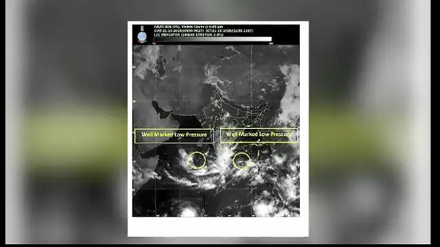
Bhubaneswar: The Meteorological Department has informed that three low pressure areas will form over the Bay of Bengal one after the other. According to the estimates of various weather models, another cyclonic circulation will form in the upper part of the South Bay of Bengal by October 23.
According to reports under its influence, a low pressure area is likely to form in the same area by the October 24 or October 25. And another low pressure area is likely to form by October 29.
The models have estimated that it may intensify. Meanwhile, a favorable low pressure area is currently active in the southwest Bay of Bengal. It will intensify further and turn into a depression by tomorrow afternoon. It will move towards the coasts of North Tamil Nadu, Puducherry, and South Andhra Pradesh. It is likely to intensify further in the next 24 hours.
However, it will not affect Odisha. The Regional Meteorological Center has predicted light to moderate rainfall with thunderstorms in various districts of the state for the next five days. Especially, South and Coastal Odisha as well as North Odisha will be affected by the rainfall.
Today, Malkangiri, Koraput Rayagada, Gajapati, Kandhamal, Ganjam, Boudh, Nayagarh, Khordha and Puri, Cuttack, Jagatsinghpur, Kendrapara districts have been issued a yellow warning for lightning and thunderstorms. Tomorrow, light to moderate rainfall is likely in coastal and south interior districts.