
Remnant of Cyclonic Storm ‘JAWAD’ to weaken into well marked low pressure area, rain predicted in Odisha

Bhubaneswar: The India Meteorological Department (IMD) today informed that the remnant of Cyclonic Storm ‘JAWAD’ to weaken into a well-marked low-pressure area in the next 12 hours and predicted rain in different parts of Odisha.
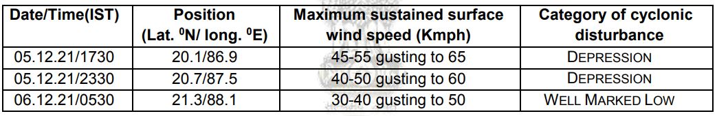
“The Depression (remnant of Cyclonic Storm ‘JAWAD’) over northwest Bay of Bengal near Odisha coast moved northeastwards with a speed of 25 kmph during past 6 hours, and lay centered at 17.30 hrs IST of today over northwest Bay of Bengal close to Odisha coast near Lat. 20.1°N and Long. 86.9°E, about 30 km southeast of Paradip (Odisha), 120 km east-northeast of Puri (Odisha) and 210 south-southwest of Sagar Island(West Bengal),” said IMD in its latest bulletin.
“It is likely to move northeastwards, towards West Bengal coast and weaken into a well-marked low-pressure area during next 12 hours,” it added.
Forecast track and intensity are given in the following table:
Meanwhile, the weatherman issued an Orange warning saying heavy rainfall very likely to occur at one or two places over the districts of Jagatsinghpur, Kendrapada, Jajpur, Bhadrak, Balasore, and
Mayurbhanj till 8.30 AM tomorrow.

 Ms Kalinga