
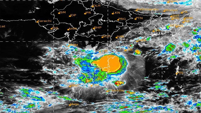
Bhubaneswar: The regional centre of the India Meteorological Department (IMD) informed that the Cyclonic Storm ‘Asani’ over the west-central Bay of Bengal moved north-north-eastwards with a speed of 4 kmph during past 6 hours, and lay centered at 2.30 PM today, over same region near latitude 16.1°N and longitude 81.4°E, about 30 km east-southeast of Machilipatnam (Andhra Pradesh), 50 km southwest of Narsapur, 120 km southwest of Kakinada (Andhra Pradesh), 270 km southwest of Visakhapatnam (Andhra Pradesh), 500 km southwest of Gopalpur and 620 km southwest of Puri.
It is very likely to move north-northeastwards along Narsapur, Yanam, Kakinada, Tuni and Visakhapatnam coasts till the evening of today and emerge into west-central Bay of Bengal off North Andhra Pradesh coasts by 12th morning. It is likely to weaken into a deep depression by tonight and further into a depression by 12th May morning.
The cyclonic storm is under the continuous surveillance of Doppler Weather Radar (DWR) at Machilipatnam (Andhra Pradesh).
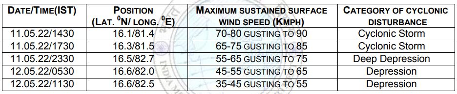
Forecast track and intensity are given in the following table:
(i) Rainfall Forecast and Warnings:
Day 1 (valid up to 0830 hrs IST of 12.05.2022):
- Forecast: Light to moderate rain or thundershower very likely to occur at many places over the districts of Odisha.
- Yellow Warning: Heavy rainfall (7-11cm) very likely to occur at one or two places over the districts of Malkangiri, Koraput, Rayagada, Nabarangpur, Gajapati, Ganjam, Keonjhar, Mayurbhanj and Balasore.
Day 2 (valid from 0830 hrs IST of 12.05.2022up to 0830 hrs IST of 13.05.2022):
- Forecast: Light to moderate rain or thundershower very likely to occur at many places over the districts of south Odisha and at a few places over the districts of North Odisha.
(ii) Wind warning:
- Gale wind speed reaching 70-80 kmph gusting to 90 kmph is prevailing around the system center over West-central Bay of Bengal. It would gradually decrease becoming 65-75 Kmph gusting to 85 Kmph by today evening over the same region. Further, it would decrease to 45-55 Kmph gusting to 65 Kmph over West-central Bay of Bengal on 12th May morning.
- Squally wind speed reaching 35-45 kmph gusting to 55 kmph is likely to continue along & off Odisha coast on 11th to 12th May.
- Sea condition: Sea condition is likely to continue to be high over westcentral & adjoining northwest Bay of Bengal till evening of 11th May and very rough to rough over the same region thereafter till 12th May.
(iii) Fishermen Warning:
- Total suspension of fishing operations over Westcentral adjoining Northwest Bay of Bengal till 12th May.
(iv) Port Warning:
- Keep hoisted Distant Warning Signal No.2 (DW-2) at all ports of Odisha.
- Possible impact and advisory: Some impact on matured agricultural crops (summer rice, Pulses (Green gram, black gram)), Vegetables and other vegetative/flowering crops (Sugarcane, Maize etc) is likely over the districts of Odisha due to rainfall.
- Harvested crop may be kept in safe place, drainage of excess water may be done, avoid irrigation & pesticides and postpone sowing of crops (Jute and others).
- Off shore activity may be regulated judiciously on 11th to 12th May, 2022.

 Kalinga AI