
Bhubaneswar: Tracks of several weather agencies and models suggest that Cyclone Asani is likely to touch the Andhra Pradesh coast and not Odisha coast.
The tracks of the European Centre for Medium-Range Weather Forecasts, American Global Forecast System (GFS) and the Joint Typhoon Warning Centre (JTWC) show that Cyclone Asani is most likely to touch the coastal areas of Andhra Pradesh and recurve but will not touch the Odisha coast.
Earlier it was said that the cyclone would not hit the land.
#CycloneAsani likely to touch Andhra coast as per the tracks of several weather agencies & models
Pic 1: European ECMWF model
Pic 2: American GFS model
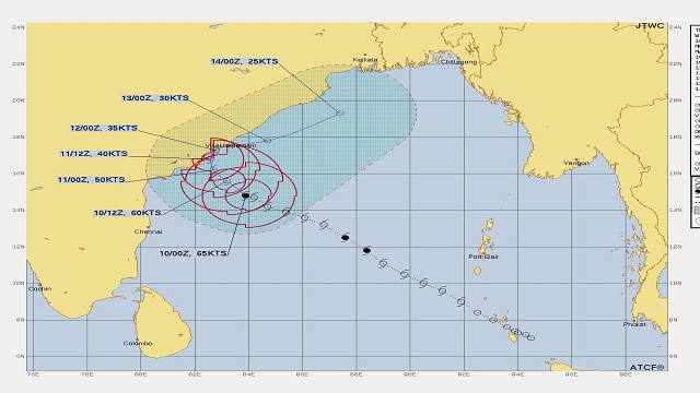
Pic 3: Track as shown by Joint Typhoon Warning Centre
Earlier it was said that Asani would not touch land pic.twitter.com/x9Nq9opZ3D
— Soumyajit Pattnaik (@soumyajitt) May 10, 2022
Meanwhile, India Meteorological Department (IMD) DG Mrutyunjay Mohapatra said that the severe cyclonic storm is likely to move nearly northwestwards till May 10 night and reach west-central Bay of Bengal off north Andhra Pradesh coast.
The IMD DG said that the system, thereafter, is very likely to recurve north-northeastwards and move towards the northwest Bay of Bengal off North Andhra Pradesh and will weaken gradually into a cyclonic storm.

 Kalinga AI