
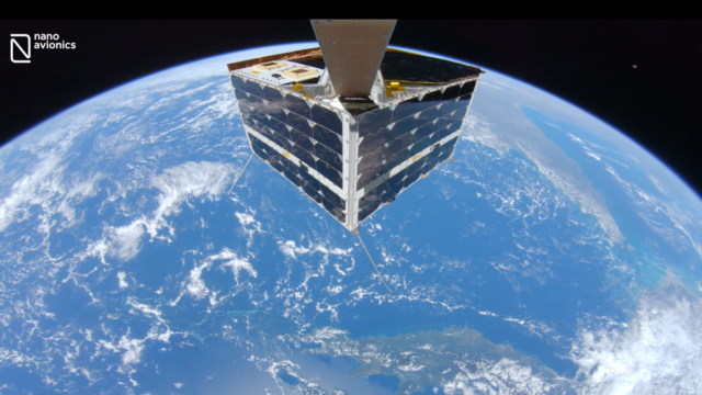
A brand new selfie taken by a spacecraft displays the device above Australia’s Great Barrier Reef in gorgeous 4K resolution. A high-definition video from space was released by the American and British satellite business NanoAvionics on Wednesday, June 28. It shows their MP42 microsatellite flying 342 miles (550 km) above the reef and the Coral Sea, which is located off the northeast coast of Australia.
The “immersive” view of Earth they were able to get with the use of a selfie stick was the first high-definition shot of a full satellite with Earth as the backdrop.It wasn’t by chance that the reef was in the background. We wanted to highlight the fragility of our planet and the necessity for Earth observation by satellites, especially for monitoring environment and climate changes,” said Vytenis Buzas, co-founder and CEO of NanoAvionics.
According to earlier data(opens in new tab) from NASA’s Jet Propulsion Laboratory, the Great Barrier Reef, which is over 133,000 square miles (344,400 square kilometres) in size, is the largest structure on Earth formed by living species (JPL). In 2016, the organisation conducted research on the Great Barrier Reef as part of its airborne CORAL mission (COral Reef Airborne Laboratory), with the goal of delivering a more thorough dataset of coral damage than was at the time accessible from space missions.
Because of human-induced global warming, coral reefs all throughout the world, including this one, are displaying severe indications of degradation. According to JPL, reefs are “degrading at alarming rates” because they are not replacing themselves as they should with flat beds of algae and sand. Although NanoAvionics included this photograph for environmental concerns, the recording also had engineering value.
The selfie was taken while the satellite’s camera checked and confirmed satellite operations for a payload controller that seeks to analyse some data in space before transmitting it back to Earth, according to officials. (Such a procedure saves significant time when evaluating regions of the world that change rapidly.)
According to representatives of NanoAvionics, additional real satellite imagery will likely be used in the future for educational and other objectives, including fault detection, micro-meteorite effects, and deployment confirmation. The spacecraft carried roughly 40 other tiny satellites to orbit on a mission known as Transporter-4, which was launched on April 1 by a SpaceX Falcon 9 rocket.

 Ms Kalinga